Saturday, December 23, 2017

Merry Christmas


Merry Christmas  to everyone , hope the future  is brighter next year .

Nanook and friends of the planet

Friday, December 8, 2017

Why the fight to stop Keystone XL is far from over

by Tim Donaghy            November 22, 2017 
This week Nebraska's Public Service Commission approved an alternate route for the Keystone XL pipeline. But that decision wasn't what the pipeline builder was hoping for -- and it shows that continued resistance will be crucial to defeating this pipeline for good.
© Amber Bracken / Greenpeace
This Monday the Nebraska Public Service Commission approved an alternate route for TransCanada’s proposed Keystone XL tar sands pipeline, and denied the company’s preferred route. The pipeline should have been rejected outright, but as the company’s grimly muted response shows, this decision by the PSC wasn’t the good news TransCanada had been hoping for.

The Keystone XL pipeline now faces significant legal, financial, and regulatory hurdles, a growing resistance movement on the ground, as well as a number of banks backing away from funding such risky and destructive projects.

With everything in front of TransCanada it’s hard to see an easy path forward for the company.

Let’s break it down.

Tell It To The Judge

Legal challenges to the Keystone XL pipeline had already started piling up before Monday’s decision.

Earlier this year environmental and grassroots groups filed suit to challenge Trump’s approval because the administration relied on an outdated and incomplete Environmental Impact Statement (EIS) that dated back to 2014. Monday’s decision may strengthen those arguments because the outdated EIS is based on a different route than what was ultimately approved, meaning that some environmental impacts may not have been properly studied. To give one example, the new route could impact new threatened and endangered species, including the pallid sturgeon.

https://twitter.com/Ed_Crooks/status/933051370168553472

The U.S. State Department has said it is reviewing the PSC decision and just today a federal judge ruled that this lawsuit can proceed, raising the possibility that further environmental reviews may be ordered before Keystone XL can move ahead.

Similarly, Dakota Rural Action, the Intertribal Council on Utility Policy, and the Yankton Sioux Tribe are involved in legal action against the state of South Dakota, which had previously approved the pipeline in that state.

Finally, groups could choose to file an appeal against the Nebraska PSC decision itself in the next 30 days.

Re-routing the pipeline could also lead to new legal headaches for TransCanada. Landowners along the new pipeline route may not have had sufficient opportunity to comment on the alternate route, and new objections and disputes could arise. TransCanada will likely need to secure  agreements with these new landowners or could be required to file eminent domain petitions to proceed with construction.


As a lawyer for the Sierra Club put it, “this decision opens up a whole new bag of (legal) issues that we can raise.” Navigating these various hurdles could be a very lengthy and potentially costly process.
Ground Resistance
Despite this approval, ground resistance to this pipeline continues to grow. The chairman of the Cheyenne River Sioux Tribe, Harold Frazier, stated that his tribe “will fight this treaty violation with any means necessary. […] We have not asked for this danger to our way of life, yet today it is being forced upon us again.”

No Keystone XL Pipeline 


Just this week in South Dakota on the Lower Brule Reservation of the Kul Wicasa Oyate, representatives of Tribal Nations gathered for the second signing of the Treaty to Protect the Sacred from tar sands. See the livestream here.

From that important gathering, a handful of groups, including Greenpeace USA, launched the “Promise to Protect”– a promise to keep the movement against this tar sands pipeline going with peaceful, creative resistance.

The Ponca Tribe of Nebraska has worked with a coalition of allies to plant Ponca Sacred Corn in the path of the proposed pipeline, and near the Ponca Trail of Tears. Similarly, at multiple locations along the pipeline route, families have built solar power arrays in its path as a concrete reminder that clean energy is a viable alternative to dirty tar sands and have plans for more.

TransCanada’s recent 200,000+ gallon spill from its existing Keystone 1 pipeline in South Dakota highlights why so many have pledged to stand against these pipelines.

This resistance is part of a growing movement opposed to the further expansion of risky and unnecessary fossil fuel infrastructure. Three proposed pipelines carrying tar sands from Alberta to ports and refineries have drawn particular opposition. Already over 150 First Nations and Tribes have declared their opposition to tar sands pipelines, rail and tanker traffic through their traditional territories and waters.

Enbridge’s proposed Line 3 expansion still has not secured final regulatory approval but has already sparked protest encampments and resistance. Kinder Morgan’s Trans Mountain pipeline which was proposed to carry tar sands bitumen from Alberta to Canada’s west coast has been greeted by the construction of tiny houses along its path, built by members of the Secwepmc Nation.

Banks Think Twice About Lending to Destructive Projects

The PSC decision was seen by some financial analysts as a sign of uncertainty for the project. Moody’s Investors Service stated that the decision “does not provide certainty that the project will ultimately be built and begin operating” and that pipeline construction “would negatively affect TransCanada’s business risk profile.”

A recent report from Greenpeace and Oil Change International, In The Pipeline, outlined the significant risks to banks and investors of these three tar sands pipelines. Major risks include:

Reputational risks from projects that could violate the human rights of indigenous communities, and that have proceeded without obtaining the Free, Prior and Informed Consent of communities impacted by the pipelines.
Reputational and financial risks from projects that pose a threat to local environments from pipeline oil spills and potential contamination of water resources. In addition to last week’s Keystone spill, a recent report from Greenpeace found that the three companies proposing to build these pipelines, and their subsidiaries, have been responsible for at least 373 spills releasing over 60,000 barrels of hazardous liquids since 2010.
Undermining other actions on climate change by bankrolling projects that are flatly inconsistent with the goals of the Paris climate accords and a healthy climate. These proposed pipelines are key to unlocking up to 2 million additional barrels per day of tar sands, one of the most environmentally destructive energy sources on the planet.
Questions over the economic viability of the pipelines. The expansion of the tar sands is also dependent on high future oil prices that may not materialize. China and a number of other countries have announced policies that could significantly reduce the demand for oil over the next decades.
In recent months a number of banks, including BNP Paribas (the 8th largest bank in the world), ING Bank, and US Bank have adopted policies to eliminate financial support for tar sands pipelines. Greenpeace has called on JPMorgan Chase to do the same. Twenty-five banks currently provide key financial services that allow these projects to proceed.

All of this shows that organized, people-powered resistance can beat powerful and wealthy corporations. The resistance to KXL is working, but we need to fight even harder to cancel this pipeline for good. Join the #PromiseToProtect and plug into a massive wave of creative resistance to stop the pipeline.


Tim Donaghy is a Senior Research Specialist with Greenpeace USA. He writes frequently about climate change, offshore oil drilling, energy production, and the Arctic.

Tuesday, December 5, 2017

Scientists express shame and anger at plastic pollution of oceans

 
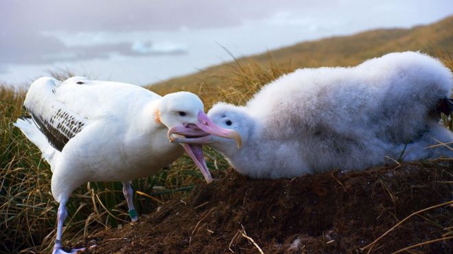
 Wandering albatrosses scour the oceans for food to bring back to their chicks 
 
Scientists who advised and consulted with the Blue Planet II documentary team say they feel "shame and anger" at the “plague of plastic” impacting the natural world.
Even in the remote waters of Antarctica, they have found evidence of plastic killing and harming seabirds. Wandering albatrosses – which have the longest wingspan of any birds alive today – are thought to be especially vulnerable.
Nesting on the barren islands of South Georgia, Antarctica, they feed their young by scouring thousands of miles of ocean for squid and fish but often bring back plastic instead and feed it to their young.  The final episode of what has become one of  the most-watched TV programs of the year explores how the oceans are threatened by human activities including overfishing and pollution.
It will be broadcast on Sunday 10 December on BBC.
 
 The final program in the series will look at some of the threats facing the oceans
 
In a particularly moving scene, Dr Lucy Quinn, a zoologist, is seen checking albatross chicks on Bird Island where she was the British Antarctic Survey’s winter manager for more than two years.
One chick that Dr Quinn found dead and later dissected was killed because a plastic toothpick that it swallowed had pierced its stomach.
Others had regurgitated plastic items including cling film, food packaging, cutlery and parts of bottles.
Dr Quinn reported, “I feel real shame and anger that humans have caused this problem.
"It’s really sad because you get to know the birds and how long it takes the parents, away for ten days at a time, to collect food for their chicks and what they bring back is plastic.
"And what’s sad is that the plague of plastic is as far-reaching as these seemingly pristine environments."


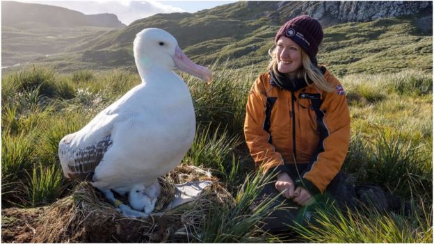
Lucy Quinn seen checking albatrosses on Bird Island, part of South Georgia
 
It's not known how many albatross chicks in Antarctica die from plastic pollution every year – it's thought to be fewer than the losses suffered by Laysan albatrossesin the Pacific .
But on Bird Island, predators often eat dead chicks before the researchers can reach them – and the suspicion is that the effect of the plastic goes beyond the direct killing of seabirds. It causes health risks to the predators too.
According to Dr Quinn, the threat is more insidious, weakening birds as they waste energy trying to digest plastic, which has no nutritional value, and potentially poisoning them as chemicals are released when the plastic breaks down in their stomachs.

Research at the other end of the world into a smaller relative of the albatross – the fulmars of the North Sea – shows that while plastics may directly kill seabirds, it is the debilitating effects of the waste that could be more serious.
 
 
 If a human had ingested the equivalent plastic volume as the average fulmar does (L), it would fill a lunchbox (R)

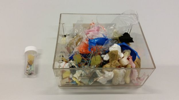
Studies of fulmars found dead on beaches or caught accidentally by fishermen – which Dr Quinn has also been involved in – show that from 2010-2014,  fulmars were found to contain on average 39 particles of plastic weighing a total of 0.32 grams.
In an unsettling image, the volume of space taken up by that plastic in a fulmar’s belly is the equivalent in a human stomach of the contents of a typical lunchbox, and usually the plastic is made up of consumer items used just once and then thrown away.

Most shocking is the effect of party balloons, released in a moment of celebration, but then catching the eye of a fulmar searching for food. Dr Quinn remembers one occasion when she dissected one of the birds.
"I couldn’t believe my eyes, seeing a balloon in the bird’s oesophagus, which would have killed it, along with cling wrap, toothbrushes and packaging – I feel extremely sad for the birds; frustrated and impatient to do something," she said.
The plastic is undermining the fulmars’ health, which could affect their ability to breed - with long-term implications for the species as a whole.
 
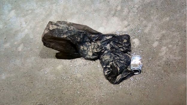
The Cayman Trough: Plastic debris has descended to the deepest parts of the world's oceans
 
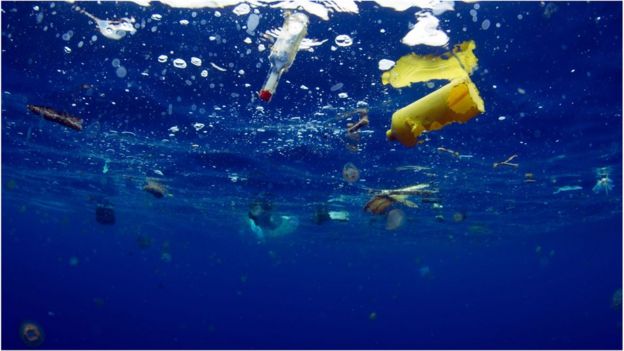
The threat from plastic waste is not limited to pieces that are visible – bottles, bags and other items break down into minute fragments, or "micro-plastics", which enter the food chain in every corner of the ocean.
Scientists from the University of Newcastle even identified tiny fibres in the smallest creatures living in the deepest part of the Pacific, the Mariana Trench.

Dr Jon Copley, of the University of Southampton, who joined the Blue Planet submarine filming in Antarctica, said, "When I've seen plastic in the deep ocean - such as a trash bin liner we found near deep-sea vents in the Cayman Trough - there's an initial shock and then deep disappointment that our garbage got here before we did as explorers."
"But then there's the realization that our everyday lives are more connected to the deep ocean than we perhaps think.
"Every piece of plastic rubbish has a story, so it also makes me wonder about the chain of events that led to that particular item ending up in the deep ocean, and whether any of those events could have been prevented."

Saturday, December 2, 2017

NASA links port-city sea levels to regional ice melt

The contribution of melting ice in Greenland to sea level rise in New York City (inset). Red indicates the greatest sea level contribution, blue is the smallest to no contribution. A new NASA tool lets users research the contributions of all regions of global land ice to sea levels in 293 port cities. Data image credit: NASA/JPL-Caltech/Google. Photo credit: Wikimedia Commons.
By Pat Brennan,
NASA's Sea Level Change Portal
A new NASA tool links changes in sea level in 293 global port cities to specific regions of melting land ice, such as southern Greenland and the Antarctic Peninsula. It is intended to help coastal planners prepare for rising seas in the decades to come.

All coastal cities will see some impacts of global sea level rise. But the new tool shows that, for example, New York City is more strongly affected by melting ice in northeastern Greenland than in southwestern Greenland; while Sydney has a greater risk from the rapidly melting Antarctic Peninsula than from East Antarctica.

A paper describing the new tool, titled "Should coastal planners have concern over where land ice is melting?," was recently published in the journal Science Advances. The research team is Eric Larour, Erik Ivins and Surendra Adhikari of NASA's Jet Propulsion Laboratory in Pasadena, California.

Melting ice and rising ocean temperatures contribute about evenly to global sea level rise today. Individual cities are also affected by local conditions such as land sinking. Other Web-based resources such as the U.S. Climate Resilience Toolkit address some of these issues, but the new NASA tool is the only resource to match specific melting ice locations with their effects on the world's ports.

Water from melted ice on land doesn't spread evenly across the world's oceans because of a gravitational push-pull between ice and ocean. As a melting glacier or ice sheet dwindles, it loses mass, causing its local gravitational pull on nearby ocean water to diminish. Seawater that had been pulled toward the ice by the force of gravity flows away — in other words, sea level drops in the vicinity of a melting glacier but rises farther away. When this spatial pattern can be attributed to a given glacier or ice sheet, it is known as a sea level fingerprint.

To calculate this and other influences on sea level such as Earth's rotation, Larour and his colleagues used a dynamic mathematical formula called the adjoint method, which is used in seismic and meteorological studies. The method enables fast computation of the sensitivity of a model's output to its inputs — in this case, the sensitivity of sea level to ice melting. They used the method with JPL's well-tested computer model of ice sheet melting, the Ice Sheet System Model, to develop their new tool, called Gradient Fingerprint Mapping.

Users of the tool need no specialized training or extreme computer power; they simply download it, input data or projections of ice loss, and let it evolve the shifting ice and water patterns forward into the future. The result: a detailed profile of the sensitivity of sea level at any of these cities to changes in ice anywhere in the world.

Calculations of sea level fingerprints have been made in previous studies but tended to be cumbersome and spatially coarse, Larour said. The new tool provides an overall mechanism for rapidly computing high-resolution results using a variety of potential data sets.

Gradient Fingerprint Mapping is not dependent on a particular climate change scenario, Larour said. "You can apply the method to any type of melting scenario that you want." That means it will retain its utility as improved projections of ice loss become available in the future.

The computations show that the specific location of mass loss in Greenland is crucial, as it greatly affects the local sea level predictions for many major coastal cities in North America and Europe. The spatial details of Antarctic melting are important for areas south of the equator in South America, Africa and South Asia.

Among some intriguing results, Larour said, are those for New York, London and Oslo. Greenland’s northeastern ice stream was shown to have an outsized effect on New York’s local sea level, but the island's southern glaciers had little influence. London was more strongly affected by Greenland’s northwestern and western glaciers. And Norway is so close to Greenland, the island's gravitational fingerprint is contributing to sea level decrease in Oslo.

The authors note that ocean dynamics can accelerate or offset the changes in sea level from gravitational fingerprints — particularly in New York, where the contribution of melting ice to accelerated sea level rise is minor compared to other sources.

“This is really a new capability,” Larour said. “Now a coastal planner can understand and see how the melting or growing of a given ice sheet could be detrimental or beneficial to a specific location.”